Search This Blog

Showing posts with label Geography. Show all posts

Saturday, August 13, 2011

Top 5 World Cities and the Ways They are Measured


The following information was collected mostly from Wikipedia, Worldatlas.com and Citymayor.com.

Its always good to know your geography and demographics!


Ambiguities in measuring the "size" of a city

The question of determining the world's largest cities does not allow a single, simple answer. It depends on which definitions of "city" and "size" are used, and how those definitions are applied. Complex political/cultural/social situations, sometimes controversial or disputed, further confuse the discussion. Debate on this field is highly vulnerable to bias or manipulation, as people[who?] tend to prefer whichever definition most flatters their own city.
The "size" of a city can refer to either its land area or, more typically, its population.
The boundaries of a city can also be defined in any of several ways:
Morphological / Urban    ( Space, Density)
"City" defined as a physically contiguous urban area, without regard to territorial or other boundaries. The delineation is usually done using some type of urban density, such aspopulation density or density of buildings (for example, "gaps between structures may not exceed 200 metres"). Satellite and/or aerial maps may be used. For statistical convenience, such areas are sometimes adjusted to appropriate administrative boundaries, yielding anagglomeration.
Functional / Metropolitan  (People, Demographics)
"City" as defined by the habits of its demographic population, as by metropolitan area, labour market area, or similar. Such definitions are usually based on commuting between home andwork. Commuter flow thresholds into the core urban area are established by the national censusauthority, determining which areas are included.
City Proper (Administrative, City Council)
"City" as strictly defined by a given government (city proper). Typically based on a municipality or equivalent entity, or sometimes a group of municipalities under a regional government.


Urban / Morph - Wikipedia 

Tokyo
Jakarta
New York
Mumbai
Manila

Urban / Morph – U.N.

Tokyo
New York
Mexico City
Mumbai
Sao Paulo

Urban / Morph - Citymayor.com

Tokyo
Mexico City
Mumbai
New York
Sao Paulo

Average:    Tokyo /  New York / Mumbai / Mexico City / Sao Paulo

Metro / Functional  – Wikipedia

Tokyo
Seoul
Mexico City
New York
Mumbai
(Jakarta, Sao Paulo)

Metro / Functional - Citymayor.com -

Tokyo
New York
Sao Paulo
Seoul
Mexico City

Metro – Worldatlas.com

1. Tokyo, Japan - 32,450,000 
2. Seóul, South Korea - 20,550,000 
3. Mexico City, Mexico - 20,450,000 
4. New York City, USA - 19,750,000 
5. Mumbai, India - 19,200,000 
(6. Jakarta, Indonesia - 18,900,000  7. Sáo Paulo, Brazil - 18,850,000 )


Average:  Tokyo /  Seoul / New York / Mexico City / Mumbai / Sao Paulo

City Proper – Wikipedia

Shanghai
Mumbai
Karachi
Delhi
Istanbul
(Sao Paulo, Moscow, Seoul, Beijing, Tokyo)

City Proper  - Citymayor.com

Karachi
Shanghai
Mumbai
Beijing
Delhi

City Proper – worldatlas.com

Shanghai, China 13.3 million
Mumbai (Bombay), India 12.6 million 
Buenos Aires, Argentina 11.92 million 
Moscow, Russia 11.3 million 
Karachi, Pakistan 10.9 million 

Average:  Shanghai / Mumbai - Karachi / Delhi / Moscow / Buenos Aires / Istanbul

Metro – Worldatlas.com

1. Tokyo, Japan - 32,450,000 
2. Seóul, South Korea - 20,550,000 
3. Mexico City, Mexico - 20,450,000 
4. New York City, USA - 19,750,000 
5. Mumbai, India - 19,200,000 
6. Jakarta, Indonesia - 18,900,000 
7. Sáo Paulo, Brazil - 18,850,000 
8. Delhi, India - 18,680,000 
9. Õsaka/Kobe, Japan - 17,350,000 
10. Shanghai, China - 16,650,000
11. Manila, Philippines - 16,300,000 
12. Los Angeles, USA - 15,250,000 
13. Calcutta, India - 15,100,000 
14. Moscow, Russian Fed. - 15,000,000 
15. Cairo, Egypt - 14,450,000 
16. Lagos, Nigeria - 13,488,000 
17. Buenos Aires, Argentina - 13,170,000 
18. London, United Kingdom - 12,875,000 
19. Beijing, China - 12,500,000 
20. Karachi, Pakistan - 11,800,000


Wednesday, July 20, 2011

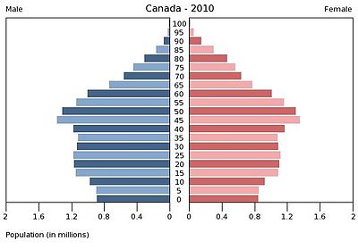
Canadian Demographics

For Geography nerds....Source: Wikipedia / Statistics Canada
Province or territory↓Population↓Percentage of national pop.↓Total area (km2)↓Population density↓Seats in House of Commons↓People per House Seat↓
Ontario13,119,25138.73%1,076,39512.19106123,767
Quebec7,856,88123.19%1,365,1285.7675104,758
British Columbia4,479,93413.23%925,1864.8436124,443
Alberta3,703,97910.93%642,3175.7728132,285
Manitoba1,226,1963.62%553,5562.221487,585
Saskatchewan1,034,9743.06%591,6701.751473,927
Nova Scotia940,3972.78%53,33817.631185,491
New Brunswick750,4572.22%71,45010.501075,046
Newfoundland and Labrador510,2721.51%373,8721.36772,896
Prince Edward Island141,3740.42%5,66024.98435,344
Northwest Territories43,2440.13%1,183,0850.037143,244
Yukon33,9630.10%474,3910.072133,963
Nunavut32,4350.10%1,936,1130.017132,435
Canada33,873,357


Canada (play /ˈkænədə/) is a North American country consisting of ten provinces and three territories. Located in the northern part of the continent, it extends from the Atlantic Ocean in the east to the Pacific Ocean in the west and northward into the Arctic Ocean. It is the world's second largest country by total area. Canada's common border with the United States to the south and northwest is the longest in the world.


In 1867, with the union of three British North American colonies throughConfederation, Canada was formed as a federal dominion of four provinces. This began an accretion of provinces and territories and a process of increasing autonomy from the United Kingdom. This widening autonomy was highlighted by the Statute of Westminster 1931 and culminated in the Canada Act 1982, which severed the vestiges of legal dependence on the British parliament.


It is a member of the G7G8G20NATOOECDWTOCommonwealth of Nations,FrancophonieOASAPEC, and UN. With the eighth-highest Human Development Index globally, it has one of the highest standards of living in the world.


A clickable map of Canada exhibiting its ten provinces and three territories, and their capitals.


Largest Metropolitan Areas:


Largest metropolitan areas in Canada by population (2006 Census)view · talk · edit
NameProvincePop.NameProvincePop.
TorontoOntario5,113,149KitchenerCambridge-WaterlooOntario451,235
MontrealQuebec3,635,571St. CatharinesNiagaraOntario390,317
VancouverBritish Columbia2,116,581HalifaxNova Scotia372,858
OttawaGatineauOntarioQuebec1,130,761OshawaOntario330,594
CalgaryAlberta1,079,310VictoriaBritish Columbia330,088
EdmontonAlberta1,034,945WindsorOntario323,342
QuebecQuebec715,515SaskatoonSaskatchewan233,923
WinnipegManitoba694,898ReginaSaskatchewan194,971
HamiltonOntario692,911SherbrookeQuebec186,952
LondonOntario457,720St. John'sNewfoundland and Labrador181,113


total: 39.5 years
  • male: 38.6 years
  • female: 40.4 years (2006)


Vital statistics


Birth rate: 10.28 births/1,000 population (2009 est.)
Death rate: 7.74 deaths/1,000 population (2009 est.)
Net migration rate: 5.63 migrant(s)/1,000 population (2009 est.)

Projected Population:

United Nations, 2010 est. [2] :
  • 2020: 37,163,000
  • 2030: 39,850,000
  • 2040: 41,882,000
  • 2050: 43,642,000
  • 2060: 45,101,000
  • 2070: 46,271,000
  • 2080: 47,206,000
  • 2090: 47,906,000
  • 2100: 48,290,000


Aboriginal status

The 2006 census counted a total Canadian Aboriginal population of 1,172,790 (3.75%) which includes 698,025 First Nations (2.23%), 389,785 Métis (1.25%), and 50,480 Inuit (0.16%). Percentages are calculated as a proportion of the total number of respondents (31,241,030)[13]
Province/Territory↓Number↓ %
provincial[14]↓
 %
national[14]↓
Indian
,(First Nations)↓
Métis↓Inuit↓Multiple [14]↓Other[14]↓
Nunavut24,91585.0%2.1%10012524,6403020
Northwest Territories20,63550.3%1.8%12,6403,5804,160105145
Yukon7,58025.1%0.6%6,27580025550190
Manitoba175,39515.5%15.0%100,64571,8055656801,695
Saskatchewan141,89014.9%12.1%91,40048,1152206251,530
Alberta188,3655.8%16.1%97,28085,4951,6051,2202,760
British Columbia196,0754.8%16.7%129,57559,4457951,6554,605
Newfoundland and Labrador23,4504.7%2.0%7,7656,4704,7152904,205
Canada1,172,7903.8%100.0%698,025389,78550,4807,74026,760
Nova Scotia24,1752.7%2.1%15,2407,680320100830
New Brunswick17,6552.5%1.5%12,3854,270185100710
Ontario242,4952.0%20.7%158,40073,6102,0401,9106,540
Quebec108,4301.5%9.2%65,08527,98010,9509553,450
Prince Edward Island1,7301.3%0.1%1,230385301075
Sources: 2006 Census[15][16][
17

Full article:  http://en.wikipedia.org/wiki/Demographics_of_Canada